Programs for the work of a cadastral engineer. Polygon - programs for all types of cadastral work. VIII. Control of acquired knowledge
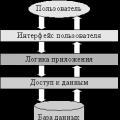
ARGO is an inexpensive but functional solution for individual cadastral engineers and large organizations. All functions for the preparation of land-surveying and technical plans, maps (plan) of boundaries, land-surveying projects and other documents.
Formation of printed forms and XML, processing of initial data and keeping records of the organization's work. Fully functional specialized for cadastral tasks graphics editor and support for network collaboration. Operational technical support and regular expansion of the program's capabilities.
ARGO provides a full cycle of work from processing initial data and keeping records of work within the organization, to issuing complete set documents in print and in electronic format.
Program Version: 7.0.5556
Developer: new.argogeo.ru
Interface language: Russian
System requirements: Windows XP / Vista / 7/8/10
Program status: ShareWare
Size: 855 MB
Added: 10/23/2017
Updated: 23.10.2017
The program contains a full-featured graphic editor specialized for the tasks being performed and supports the simultaneous work of all employees of the organization over the network. Prompt technical support is provided on a daily basis by phone and via the Internet, there is the possibility of remote connection of technical support staff to your workplace to resolve emerging issues in each specific situation. The program is constantly being improved, new functions are added and the work of existing ones is optimized. The released updates are sent free of charge to all current users of the program.
ARGO capabilities
- Land-surveying and technical plans of any complexity, Scheme of the location of the memory on the KPT, Declarations, Map (plan), Land surveying project, Information about zones and boundaries, Survey reports, Map (plan) of the territory and other documents required for cadastral registration of real estate objects are available immediately after installation.
- Formation of applications to the State Property Committee from boundary and technical plans, sending them to the Rosreestr portal directly from the program, receiving and viewing the results of considering applications.
- Full automation of the workflow from entering the results of field measurements to the issuance of a set of documents signed with an EDS, ready for delivery to the cadastral registration authorities or sending through the Rosreestr portal.
- Integration with the Public cadastral map: searching for accounting objects and viewing their properties, importing raster substrates from a public cadastral map to a drawing.
- The system of accounting and analysis of applications, the formation of invoices, contracts, acceptance certificates, salary calculation and analysis of the work of employees and many other useful functions.
- Client-server architecture, access to a database with drawings and cases from any computer of the organization with the ability to work in parallel with one application. Centralized security management and backup all data in two clicks.
- The ability to import XML documents and Zip-archives uploaded for delivery to the State Property Committee (including from programs of other manufacturers), such as landmarks and technical plans, as well as documents containing information about zones and boundaries.
- Intuitive and easy to use user interface using the most modern technologies.
- Fast import of statements of all formats, regardless of volume.
- Data exchange with common software (import and export XML, DXF (AutoCad), MIF (MapInfo), reading measurement results from geodetic equipment).
- Technical support meets the highest standards and is available using any convenient communication channel (phone, Skype, ICQ, website). If necessary, our employee is ready to connect to your desktop for on-site assistance.
- Low cost of use is guaranteed by the absence of the need for additional software.
- The module for preparing drawings of our own design, which has an intuitive interface, is made taking into account all the requirements for cadastral work.
The set of programs "ARM cadastral engineer» - automated workplace a cadastral engineer based on the GIS "Panorama 2011 Mini" and a set of tasks "Cadastral tasks" from the Complex of geodetic calculations.
The software that is part of the workplace allows you to generate land management documentation, load coordinates from text files various formats, process data from GPS receivers.
More than 125 types of templates for land management documents are supplied with the software. Reports can be generated in formats Microsoft Office or OpenOffice. Supported electronic document flow with an automated system of the state cadastre of real estate, loading XML-schema cadastral extract about the real estate object and uploading the XML-schema of the boundary plan.
Possibilities of the set of programs "Workstation of a cadastral engineer":
- Loading and viewing vector maps from SXF, TXF, OGC GML (XML), KML (Google), DXF, Shape, MIF \ MID, S57, GDF, DGN, MP (Polish format), XLS, DBF, TXT formats, OziExplorer formats (WPT, RTE, PLT, EVT), Magellan Explorist UPT, RTE), raster data (RSW, BMP, JPEG, GeoTIFF, TIFF), MrSID rasters (SID, JPEG 2000, NITF), multispectral images (GeoTIFF), DEM , quality matrices, geological matrices of layers, TIN-models, laser scanning data (point cloud in MTD format), custom maps, area of work.
- Creation of new maps with automatic filling of parameters using the EPSG code or from the list of parameters in XML format.
- Calculation of parameters of local coordinate systems based on a set of points with known coordinates in MSK and GSK.
- Editing vector maps. Entering texts of signatures and attribute values in UNICODE. Combining and editing vector maps of different projections in one document.
- Connection to GIS Server 2011 for multiuser work with access control.
- Data search, data composition management through the Map Legend.
- Connection of databases of various formats.
- Connect Google Earth, Digital Globe.
- Import of data from servers using OGC WMS and OGC WFS protocols.
- Connection to the GIS Server to ensure collective work and control access to data.
- Connection to a GPS / GLONASS receiver for solving navigation problems.
- Seal e-card on different devices output and output to PostScript.
- Preview of the document prepared for printing, setting the parameters for printing small runs of cards.
- Complete documentation, electronic help system.
Information about land plots and their parts can be drawn up in the form of reports or saved in an XML file for subsequent electronic cadastral registration.
The formation of land management documentation is provided by the following functions:
Drawing on the cadastral map of the object composition for the description of land use (quarters, plots, zones of restrictions, buildings, landmarks);
- input, editing, storage and subsequent use of land use accounting data;
- setting the parameters of the attribute data for the description of land use;
- establishing a link between a map feature and land-use attribute data records;
- creation of new and customization of existing templates for reporting documents;
- formation of a land use scheme according to the parameters specified by the user;
- automatic filling of the report according to the specified template in accordance with the metric and attributive data of land use;
- support for the generation of reports for unified land use, consisting of several parts;
- formation of a boundary plan, including for multi-contour objects;
- support of information exchange with the AIS GKN, through XML files - information about the objects of the real estate cadastre;
- the formation of outlines of turning points of land use.
The landline plan is formed in accordance with the requirements for the preparation of the landline plan, approved by the order of the Ministry of Economic Development Russian Federation No. 412 dated November 24, 2008
The map (plan) of the land management object is formed in accordance with the requirements for drawing up a map (plan) of the land management object, approved by the Decree of the Government of the Russian Federation No. 621 of July 30, 2009.
AWP (workstation automation) of a cadastral engineer... In this section, I will give a list of programs for boundary and cadastral plans, which one way or another, may be needed in the work cadastral engineer, as well as programs general purpose, which I use for the implementation of cadastral and the formation of boundary and technical plans. Which you can download either by direct link, or right here. The top lines of the table are occupied by those programs for cadastral engineer, which I have tested and all my comments are purely subjective. I'm just sharing my experience. Below is a list of programs to make life easier cadastral engineer... In the list of programs, there are programs for signing XML files Rosreestra, electronically digitally signed, as well as programs that allow you to work both with the official website of Rosreestr and with the Rosreestr web service.
In principle, the clear sales leaders from the programs for the formation of boundary and technical plans are - Technocad (he began to take by the fact that he was the first to implement registration in electronic form, which often eliminated the need to make a landline plan in paper form) and Polygon Boundary plan. Polygon - operational technical support.
Program name and MY short description
List useful programs and documents that may be useful to a cadastral engineer
- – Avant Browser is free software. 100% free! No ads, no viruses, no spyware scripts, no malware... Alternative to InternetExplorer. Rosreestr accepts this browser friendly and signs the EDS. Auto filling of forms is present.
- doPDF 7.3 . – free PDF converter for Windows 8, 7, Vista, XP, 2008/2003/2000 Server (32 and 64-bit). Used to create multi-page PDF files when submitting documents to Rosreestr.
- used by Federal Service state registration, cadastre and cartography in automated systems maintaining the Unified State Register of Rights to Real Estate and Transactions with It and the State Real Estate Cadastre.
Introduction ………………………………………………………………………… ..3
1 Cadastral engineer ………………………………………………… 4-5
2 Programs for a cadastral engineer …………………… ....................... 6
2.1 Program name and short description ………………………… 6
XML file validation software for XML compliance
schemes located on the official website of Rosreestr ……………… .7
2.3 A list of useful programs and documents that may be useful to a cadastral engineer ……………………………………… ... 7
2.4 Using the AutoCAD program by cadastral engineers ... 7-8
Conclusion ……………………………………………………………………… .9
List of sources used ……………………………………… ..10
Introduction
In this analytical review, I will tell you who cadastral engineers are, how you can become, what needs to be done for this. You will also learn about the programs that a cadastral engineer should master and their brief description. XML File Compliance Checker XML schemas located on the official website of Rosreestr . A list of useful programs and documents that may be useful to a cadastral engineer. What is AutoCAD program? How it is used. And at the end you will find a conclusion.
Cadastral engineer
Cadastral engineer- an individual carrying out cadastral activities who has a valid qualification certificate of a cadastral engineer.
A cadastral engineer can also carry out land surveying.
A qualification certificate of a cadastral engineer is issued to an individual on the basis of passing a qualification exam, as well as subject to the following requirements:
Has the citizenship of the Russian Federation;
Has a secondary vocational education in one of the specialties determined by the regulatory body in the field of cadastral relations, or a higher education obtained in a state-accredited educational institution of higher professional education;
Has no outstanding or unexpunged conviction for an intentional crime.
Qualification certificates issued by the executive authorities of the constituent entities of the Russian Federation to persons who have passed certification for compliance with the qualification requirements for cadastral engineers². A qualification certificate is issued without any time limit, territory of its validity and is a document of a unified federal standard.
Cadastral engineer has the right to choose the form of organizing its cadastral activities, which may be as follows:
1. as an individual entrepreneur;
2.as an employee legal entity on the basis of an employment contract with such a legal entity.
Each cadastral engineer must have a seal, stamps, forms, which indicate, in particular, his address and an identification number his qualification certificate.
The basis for carrying out cadastral works by a cadastral engineer is a work contract concluded with the Customer. The result of cadastral works are documents that the cadastral engineer must transfer to the Customer, namely:
1. landline plan;
2. technical plan (according to order 577 of 10/14/2011, the technical plan is made by cadastral engineers depending on the territory where the capital construction object is located since 2012);
3. inspection report (according to order 577 of 10/14/2011, the inspection report by cadastral engineers is made depending on the territory where the capital construction object is located since 2012).
Cadastral Engineer Programs.
AWP (workstation automation) of a cadastral engineer... This section provides a list of programs for land-surveying and cadastral plans, which, one way or another, may be needed in the work of a cadastral engineer, as well as general-purpose programs that are used to carry out cadastral and form land and technical plans. In the list of programs, there are programs for signing XML files of the Rosreestr, with an electronic digital signature, as well as programs that allow you to work both with the official website of Rosreestr and with the Rosreestr web service.
In accordance with clause 10 of part 2 of article 29.1 of the Federal Law of July 24, 2007 No. 221-FZ "On the State Real Estate Cadastre" (Collected Legislation of the Russian Federation, 2007, No. 31, Art. 4017; 2008, No. 30, Art. 3597 , 3616; 2009, No. 1, Art. 19; No. 19, Art. 2283; No. 29, Art. 3582; No. 52, Art. 6410, 6419; 2011, No. 1, Art. 47; No. 23, Art. 3269 ; No. 27, Art. 3880; No. 30, Art. 4563, 4594, 4605; No. 49, Art. 7024, 7061; No. 50, Art. 7365; 2012, No. 31, Art. 4322; 2013, No. 14, Art. 1651; No. 23, Art. 2866; No. 27, Art. 3477; No. 30, Art. 4083; 2014, No. 26, Art. 3377; No. 30, Art. 4211, 4218; No. 43, Art. 5799, 5802 ; No. 45, Art. 6145; No. 52, Art. 7558; 2015, No. 1, Art. 39, 52; No. 9, Art. 1193; No. 14, Art. 2019; No. 27, Art. 3975, 3997; No. 29, Articles 4339, 4359, 4370, 4377, 4378, 4385; 2016, No. 1, Articles 11, 51, 72; No. 18, Articles 2484, 2495; No. 27, Articles 4198, 4294), paragraph 2 Part 7 of Article 76 of the Federal Law of December 29, 2012 No. 273-FZ "On Education in the Russian Federation" (Collected Legislation of the Russian Federation, 2013, No. 19, Art. 2326; No. 23, art. 2878; No. 27, art. 3462; No. 30, art. 4036; No. 48, art. 6165; 2014, no. 6, art. 562, 566; No. 19, art. 2289; No. 22, art. 2769; No. 23, art. 2933; No. 26, art. 3388; No. 30, art. 4217, 4257, 4263; 2015, no. 1, art. 42, 53; No. 18, art. 2625; No. 27, art. 3951, 3989; No. 29, art. 4339, 4364; No. 51, art. 7241; 2016, no. 1, art. 8, Art. nine; 78; No. 10, art. 1320; No. 23, art. 3289, 3290; No. 27, art. 4160, 4219, 4223, 4238, 4239, 4246, 4292) I order:
Approve:
a typical additional professional program (professional retraining program) "Cadastral activities" ();
a typical additional professional program " Modern technologies in the field of cadastral activities "();
a typical additional professional program (professional development program) " Actual problems interaction of subjects of cadastral relations "();
a typical additional professional program (professional development program) "Current issues of legislation in the field of cadastral activities" ().
Registration number 43970
Appendix No. 1
to the Ministry
economic development of the Russian Federation
dated August 24, 2016 No. 541
(professional retraining program)
"Cadastral activity"
I. General Provisions
1. A typical additional professional program (professional retraining program) "Cadastral Activities" (hereinafter referred to as the Program) was developed in accordance with the provisions of the Federal Law of December 29, 2012 No. 273-FZ "On Education in the Russian Federation" (Collected Legislation of the Russian Federation, 2013, No. 19, Art. 2326; No. 23, Art. 2878; No. 27, Art. 3462; No. 30, Art. 4036; No. 48, Art. 6165; 2014, No. 6, Art. 562, 566; No. 19 , Art. 2289; No. 22, Art. 2769; No. 23, Art. 2933; No. 26, Art. 3388; No. 30, Art. 4217, 4257, 4263; 2015, No. 1, Art. 42, 53; No. 18 , p. 2625; No. 27, p. 3951, 3989; No. 29, p. 4339, 4364; No. 51, p. 7241; 2016, No. 1, p. 8, 9; p. 24, 78; No. 10, 1320; No. 23, Articles 3289, 3290; No. 27, Articles 4160, 4219, 4223, 4238, 4239, 4246, 4292), taking into account the requirements of the order of the Ministry of Education and Science of Russia dated July 1, 2013 No. 499 "On approval The procedure for organizing and carrying out educational activities for additional professional programs "(registered by the Ministry of Justice of Russia on August 20, 2013, p. registration number No. 29444), as amended by order of the Ministry of Education and Science of Russia dated November 15, 2013 No. 1244 "On Amendments to the Procedure for Organizing and Implementing Educational Activities for Additional Professional Programs, approved by order of the Ministry of Education and Science of the Russian Federation dated July 1, 2013 No. No. 499 "(registered by the Ministry of Justice of Russia on January 14, 2014, registration number No. 31014) and the federal state educational standard of higher education in the field of training on March 21, 2002 Land management and cadastres (bachelor's level), approved by order of the Ministry of Education and Science of Russia dated October 1, 2015 . No. 1084 (registered by the Ministry of Justice of Russia on October 21, 2015, registration No. 39407).
2. Professional retraining of interested persons (hereinafter - listeners), carried out in accordance with the Program, can be carried out at the choice of the educational organization in accordance with the curriculum in full-time, part-time, part-time education using e-learning and distance learning technologies.
3. Sections included in the curriculum of the Program are used for the subsequent development of the calendar curriculum, curriculum, work programs, methodological and assessment materials. The listed documents are developed by the educational organization independently, taking into account the current provisions of the legislation on education and legislation on the implementation of cadastral activities, state cadastral registration and state registration of rights to real estate, land management, geodesy, cartography and related fields of knowledge.
4. The program regulates the requirements for the level of professional retraining in the field of cadastral activities and determines the minimum amount of knowledge and skills that a cadastral engineer must have when performing cadastral work.
The standard term for mastering the Program is 600 academic hours.
Individuals with or receiving higher education are allowed to master the Program.
5. The area of professional activity of a cadastral engineer includes the implementation of cadastral work in relation to real estate, as a result of which the preparation of documents containing information on such real estate necessary for the implementation of cadastral registration is provided, and the provision of other services in cases established by the legislation of the Russian Federation.
The objects of professional activity of a cadastral engineer are: land plots, buildings, structures, premises, parts of such real estate objects, objects of construction in progress, as well as other real estate objects subject to cadastral registration in accordance with federal legislation.
Professional activities of a cadastral engineer: design, production and technology, research, organizational and management.
II. Purpose of professional retraining
6. The purpose of professional retraining in the field of cadastral activities is the acquisition of new professional competencies by students necessary for the performance of cadastral work, as well as the implementation of the requirements of the legislation of the Russian Federation in terms of mandatory conditions for natural person a member of the self-regulatory organization of cadastral engineers.
III. Planned results of professional retraining
7. The result of professional retraining of trainees under the Program is to increase the level of their professional competencies through the acquisition of knowledge and skills in the field of cadastral activities in the Russian Federation.
8. A student who has mastered the Program must have the following general professional competencies:
The ability to search, store, process and analyze information from various sources and databases, to present it in the required format using information, computer and network technologies(OPK-1);
The ability to use knowledge of modern technologies for design, cadastral and other works related to land management and cadastres (OPK-3).
A student who has mastered the Program must have professional competencies:
The ability to use knowledge for land management, real estate, organization and conduct of cadastral and land management works (PC-2);
2) project activities:
The ability to use knowledge of the regulatory framework and methods for developing design solutions in land management and cadastres (PC-3);
3) research activities:
The ability to conduct and analyze the results of research in land management and cadastres (PC-5);
4) production and technological activities:
The ability to use knowledge of modern technologies for collecting, systematizing, processing and recording information about real estate objects of modern geographic and land information systems (PC-8);
The ability to use the knowledge of modern technologies when carrying out land management and cadastral works (PC-10);
Ability to use knowledge of modern technologies for technical inventory of capital construction objects (PC-12).
2) Disciplinary competence map of the OPK-3
3) Disciplinary competence map PC-2
4) Disciplinary map of competence PC-3
5) Disciplinary map of competence PC-5
6) Disciplinary competence map PK-8
7) Disciplinary map of competence PK-10
8) Disciplinary map of competence PK-12
10. As a result of mastering the Program, the student must:
General provisions and sources of civil, land, urban planning, environmental law and others;
Land management technology;
Regulation of land use and protection;
Modern classification of state geodetic networks, principles and methods of constructing geodetic networks for special purposes (reference boundary networks), methods, techniques and modern technical means performing geodetic works, software for processing the results of geodetic measurements;
Fundamentals of aerospace surveys, metric and decoding properties of various information models, fundamentals of digital photogrammetric image processing technology;
Basic concepts and definitions from the theory of cartography, the theory of cartographic projections and the theory of generalization, ways of displaying thematic content on maps;
Purpose and principle of work with geographic information systems (hereinafter - GIS systems);
Basics of spatial planning, land management and zoning of the territory of land management facilities;
Goals, objectives, principles and content of state monitoring of land and other real estate;
Use data from aerial and satellite images and other materials for remote sensing of the Earth;
Possess the methods of creating and using cartographic materials using geoinformation technologies (hereinafter referred to as GIS technologies);
Conduct cadastral work in relation to immovable property, as a result of which the preparation of documents containing the information necessary for the implementation of cadastral registration of such immovable property is ensured;
Apply methods of land management design in solving practical problems in the formation of real estate objects.
Have skills:
Work with modern geodetic instruments, mathematical processing of field measurements and construction on their basis of planning and cartographic materials;
Preparation of documents for state cadastral registration and registration of rights to real estate using specialized software.
IV. Syllabus
11. The volume of the Program is 600 hours.
For persons with in-depth training in individual disciplines of the Program, a form of organization of educational activities based on a modular principle, with the organization of the educational process according to an individual plan, can be used.
When mastering the Program, it is possible to credit academic disciplines (modules) mastered in the process of previous training in the main professional educational programs and (or) additional professional programs, the order of which is determined by the educational organization independently.
12. The curriculum of the Program determines the list, sequence, general labor intensity of disciplines and forms of knowledge control.
The program includes general professional disciplines and special disciplines.
Testing;
Control and term papers;
Sample curriculum
professional retraining programs
"Cadastral activity"
| P / p No. | Name of disciplines | Total labor intensity (600 hours) |
|---|---|---|
| 1 | 24 | |
| 2 | 108 | |
| 3 | 12 | |
| 4 | Geodesy | 90 |
| 5 | 24 | |
| 6 | Cartography | 24 |
| 7 | 126 | |
| 8 | 18 | |
| 9 | Land management | 54 |
| 10 | 12 | |
| 11 | 12 | |
| 12 | 66 | |
| 13 | final examination | 30 |
| Total: | 600 |
13. Matrix of correlating the disciplines of the curriculum of the Program and the general cultural and professional competencies formed in them
| P / p No. | Name of the discipline | Total, hours | Competencies | |||||||
|---|---|---|---|---|---|---|---|---|---|---|
| general professional | professional | |||||||||
| OPK-1 | OPK-3 | PC-2 | PC-3 | PC-5 | PC-8 | PC-10 | PC-12 | |||
| 1 | Classification of real estate objects | 24 | + | + | - | - | - | + | - | - |
| 2 | Legal basis for cadastral activities | 108 | + | - | - | - | - | - | - | - |
| 3 | Self-regulation of cadastral activities | 12 | - | - | + | - | - | - | + | - |
| 4 | Geodesy | 90 | + | + | + | - | - | + | - | - |
| 5 | Photogrammetry and Earth Remote Sensing | 24 | + | + | + | - | - | - | - | - |
| 6 | Cartography | 24 | + | + | + | - | - | + | - | - |
| 7 | Real estate cadastral works | 126 | + | + | + | + | - | + | + | + |
| 8 | Territorial planning | 18 | + | - | - | - | - | - | - | - |
| 9 | Land management | 54 | + | + | - | - | - | - | - | - |
| 10 | State regulation of the real estate market | 12 | + | - | - | - | - | - | - | - |
| 11 | State monitoring of lands | 12 | + | - | - | - | - | + | - | - |
| 12 | State cadastral registration and state registration of rights to real estate | 66 | - | + | - | - | - | + | - | + |
| 13 | final examination | 30 | + | + | + | + | + | + | + | + |
| Total: | 600 | |||||||||
14. The educational calendar is a schedule of the educational process that sets the sequence and duration of training and final certification for academic weeks and (or) days. The curriculum of the Program determines the thematic content of the disciplines, the sequence of sections and (or) topics and their complexity.
Vi. Work programs of disciplines
15. Working programm each discipline contains a list of sections and (or) topics, as well as the issues considered in them, taking into account their complexity.
Work programs for each discipline are developed by the educational organization independently, taking into account the current provisions of the legislation on the implementation of cadastral activities, state cadastral registration and state registration of rights to real estate, land management, geodesy, cartography and related fields of knowledge.
Vii. List and composition of reporting work performed by students
16. In the course of mastering the Program, each student performs the following reporting work:
VIII. Control of acquired knowledge
17. Control of the knowledge gained by students in mastering the disciplines of the Program is carried out in the following forms:
Testing for self-control - available to students throughout the entire period of professional retraining;
Control testing - completes the study of a separate discipline.
Questions and answers of test tasks should reflect the content of the discipline, taking into account the goals of its development.
IX. Organizational and pedagogical conditions for the implementation of the Program
18. The choice of teaching methods for each lesson is determined taking into account the fact that the Program is focused on partial or full use e-learning and distance learning technologies.
19. The educational process is organized using innovative technologies and teaching methods that can provide students with knowledge, skills and abilities in the field of cadastral activities, including the development of the legal framework and technologies for performing geodetic, cartographic and cadastral work, remote sensing of the Earth, territorial planning, land management , state monitoring of land and other real estate, state cadastral registration and state registration of rights to real estate using information and telecommunication technologies.
20. The implementation of the Program is ensured by the scientific and pedagogical staff of the educational organization, it is permissible to attract highly qualified specialists to the educational process from among the leaders and leading specialists of state bodies, institutions, as well as teachers of leading Russian and foreign educational organizations.
X. Forms of certification
21. In the course of mastering the Program, students perform reporting work (at the discretion of the educational organization) described in this Program. Students who have successfully completed all elements of the curriculum are admitted to the final certification.
The form of the final certification is determined by the organization carrying out educational activities independently.
22. Based on the results of professional retraining, students who have successfully mastered the Programs and passed the final certification are issued a diploma of professional retraining of the established form, which gives the right to conduct professional activities in the field of cadastral activities.
When mastering the Program in parallel with obtaining higher education, a diploma of professional retraining is issued simultaneously with the receipt of the corresponding certificate of education and qualifications.
23. Persons who have not passed the final certification or received unsatisfactory results at the final certification, as well as persons who have mastered part of the Program and (or) expelled from the educational organization, are issued a certificate of training or of the training period according to the model independently established by the educational organization.
Appendix No. 2
to the Ministry
economic development of the Russian Federation
dated August 24, 2016 No. 541
Typical additional professional program
(professional development program)
"Modern technologies in the field of cadastral activities"
I. General Provisions
1. A typical additional professional program (advanced training program) "Modern technologies in the field of cadastral activities" (hereinafter - DPP) was developed in accordance with the provisions of the Federal Law of December 29, 2012 No. 273-FZ "On Education in the Russian Federation" (Collection legislation of the Russian Federation, 2013, No. 19, Art. 2326; No. 23, Art. 2878; No. 27, Art. 3462; No. 30, Art. 4036; No. 48, Art. 6165; 2014, No. 6, Art. 562, 566; No. 19, Art. 2289; No. 22, Art. 2769; No. 23, Art. 2933; No. 26, Art. 3388; No. 30, Art. 4217, 4257, 4263; 2015, No. 1, Art. 42, 53; No. 18, Art. 2625; No. 27, Art. 3951, 3989; No. 29, Art. 4339, 4364; No. 51, Art. 7241; 2016, No. 1, Art. 8, 9; No. 1, Art. 24, 72, 78; No. 10, Art. 1320; No. 23, Art. 3289, 3290; No. 27, Art. 4160, 4219, 4223, 4238, 4239, 4246, 4292), taking into account the requirements of the order of the Ministry of Education and Science of Russia dated 1 July 2013 No. 499 "On approval of the Procedure for organizing and carrying out educational activities for additional professional programs" (registered by the Ministry of Justice of the Russian Federation Russia August 20, 2013, registration No. 29444), as amended by order of the Ministry of Education and Science of Russia dated November 15, 2013 No. 1244 "On Amending the Procedure for the Organization and Implementation of Educational Activities for Additional Professional Programs, approved by order of the Ministry of Education and Science of the Russian Federation of July 1, 2013 No. 499 "(registered by the Ministry of Justice of Russia on January 14, 2014, registration number No. 31014) and the federal state educational standard of higher education in the field of preparation 03.21.02 Land management and cadastres (bachelor's level), approved by order of the Ministry of Education and Science of Russia from October 1, 2015 No. 1084 (registered by the Ministry of Justice of Russia on October 21, 2015, registration No. 39407).
II. Purpose of preparation
1) project activities:
Ability to use knowledge of the regulatory framework and methods for developing design solutions in land management and cadastres (PC-3);
Ability to conduct and analyze the results of research in land management and cadastres (PC-5);
3) production and technological activities:
Ability to use knowledge of modern technologies for collecting, systematizing, processing and recording information about real estate objects of modern geographic and land information systems (PC-8);
Ability to use knowledge of modern technologies when carrying out land surveying and cadastral works (PC-10);
Ability to use knowledge of modern technologies for technical inventory of capital construction objects (PC-12).
9. The competency map reveals the component composition of the competence, technologies for its formation and assessment:
1) Disciplinary map of competence PC-3
2) Disciplinary map of competence PC-5
4) Disciplinary competence map PK-10
5) Disciplinary competence map PK-12
Modern classification of state geodetic networks, principles and methods of constructing geodetic networks for special purposes (reference boundary networks), methods, techniques and modern technical means for performing cadastral work, software for processing measurement results;
Appointment, grounds and procedure for performing cadastral works;
The main provisions of the regulatory framework in the field of relations arising in connection with the implementation in the territory of the Russian Federation of state registration of rights to real estate, state cadastral registration of real estate, as well as maintaining the Unified State Register of Real Estate and providing information contained in the Unified State Register of Real Estate ( from January 1, 2017).
Apply regulatory legal documents and instructions in the practice of carrying out cadastral activities;
Apply modern technical means and software when performing cadastral works;
Have skills:
Work with modern geodetic instruments, mathematical processing of field measurements and construction on their basis of planning and cartographic materials;
Preparation of documents for state cadastral registration and registration of rights to real estate objects using specialized software.
IV. Syllabus
The educational activities of students include the following types of training sessions and educational work:
Practical / independent work;
Final certification (in the form determined by the organization carrying out educational activities independently).
An approximate curriculum of the advanced training program "Modern technologies in the field of cadastral activities"
| P / p No. | Name of sections | Total, hours | Professional competencies | |||
|---|---|---|---|---|---|---|
| PC-3 | PC-5 | PC-10 | PC-12 | |||
| 1 | Land cadastral works. Results of cadastral works | 16 | + | + | + | - |
| 2 | Cadastral works in relation to buildings, structures, premises or objects of construction in progress. Results of cadastral works | 16 | + | + | + | + |
| 3 | Complex cadastral works. Results of complex cadastral works. | 6 | + | + | + | - |
| 4 | final examination | 2 | + | + | + | + |
V. Curriculum calendar and curriculum
The calendar curriculum and the curriculum are developed by the educational organization independently, taking into account the chosen form of study (full-time, part-time, part-time with the use of e-learning and distance educational technologies).
Vi. Working programm
VIII. Forms of certification
18. Mastering the DPP ends with the final attestation of students in the form determined by the organization carrying out educational activities independently.
20. Persons who have not passed the final certification or received unsatisfactory results at the final certification, as well as persons who have mastered part of the DPP and (or) expelled from the educational organization, are issued a certificate of training or a training period according to the model independently established by the organization.
Appendix No. 3
to the Ministry
economic development of the Russian Federation
dated August 24, 2016 No. 541
Typical additional professional program
(professional development program)
"Actual problems of interaction of subjects of cadastral relations"
I. General Provisions
1. A typical additional professional program (advanced training program) "Actual problems of interaction of subjects of cadastral relations" (hereinafter - DPP) was developed in accordance with the provisions of the Federal Law of December 29, 2012 No. 273-F3 "On education in the Russian Federation" (Collection legislation of the Russian Federation, 2013, No. 19, Art. 2326; No. 23, Art. 2878; No. 27, Art. 3462; No. 30, Art. 4036; No. 48, Art. 6165; 2014, No. 6, Art. 562, 566; No. 19, Art. 2289; No. 22, Art. 2769; No. 23, Art. 2933; No. 26, Art. 3388; No. 30, Art. 4217, 4257; 4263; 2015, No. 1, Art. 42, 53; No. 18, Art. 2625; No. 27, Art. 3951, 3989; No. 29, Art. 4339, 4364; No. 51, Art. 7241; 2016, No. 1, Art. 8, 9, 24, 72, 78 ; No. 10, Art. 1320; No. 23, Art. 3289, 3290; No. 27, Art. 4160, 4219, 4223, 4238, 4239, 4246, 4292), taking into account the requirements of the order of the Ministry of Education and Science of Russia dated July 1, 2013 No. 499 "On approval of the Procedure for the organization and implementation of educational activities for additional professional programs" (registered by the Ministry of Justice of the R Russia August 20, 2013, registration No. 29444), as amended by the order of the Ministry of Education and Science of Russia dated November 15, 2013 No. 1244 "On Amending the Procedure for the Organization and Implementation of Educational Activities for Additional Professional Programs, approved by order of the Ministry of Education and Science of the Russian Federation of July 1, 2013 No. 499 "(registered by the Ministry of Justice of Russia on January 14, 2014, registration number No. 31014) and the federal state educational standard of higher education in the field of preparation 03.21.02 Land management and cadastres (bachelor's level), approved by order of the Ministry of Education and Science of Russia from October 1, 2015 No. 1084 (registered by the Ministry of Justice of Russia on October 21, 2015, registration No. 39407).
2. Professional development, carried out in accordance with the DPP (hereinafter referred to as training), can be carried out at the choice of the educational organization in accordance with the curriculum in full-time, part-time, part-time forms of education using e-learning and distance learning technologies.
3. Sections included in the curriculum of the DPP are used for the subsequent development of the calendar curriculum, curriculum, work program, assessment and teaching materials. The listed documents are developed by the educational organization independently, taking into account the current provisions of the legislation on education and legislation on the implementation of cadastral activities, state cadastral registration and state registration of rights to real estate and related fields of knowledge.
4. DPP determines the minimum amount of knowledge and skills that a cadastral engineer must have when performing cadastral work, taking into account the requirements of regulatory legal documents.
The normative term for mastering the DPP is 40 academic hours.
5. Students of the DPP can be cadastral engineers or other persons with higher education (hereinafter - listeners).
II. Purpose of preparation
6. The purpose of training students for DPP is to improve the competencies necessary for the professional activity of a cadastral engineer.
III. Planned results of preparation
7. The results of the training of trainees on the DPP is an increase in the level of their professional competencies by updating their knowledge and skills in the field of cadastral activities in the Russian Federation.
Ability to use knowledge of modern technologies for design, cadastral and other works related to land management and cadastres (OPK-3).
In the course of mastering the DPP, the student improves the following professional competencies:
1) organizational and management activities:
2) production and technological activities:
Ability to use knowledge of modern technologies for collecting, systematizing, processing and recording information about real estate objects of modern geographic and land information systems (PC-8).
9. The competency map reveals the component composition of the competence, technologies for its formation and assessment:
1) Disciplinary competence map of the OPK-3
3) Disciplinary map of competence PK-8
10. As a result of mastering the DPP, the student must:
The main provisions of the regulatory framework in the field of relations arising in connection with the implementation in the territory of the Russian Federation of state registration of rights to real estate, state cadastral registration of real estate, as well as maintaining the Unified State Register of Real Estate and providing information contained in the Unified State Register of Real Estate;
Requirements for documents provided for the implementation of state cadastral registration and (or) state registration of rights;
The most common grounds in the practice of a cadastral engineer for suspending and (or) refusing to carry out state cadastral registration and (or) state registration of rights by decision of the state registrar of rights.
Apply regulatory legal documents and instructions in the practice of carrying out cadastral activities;
Request the information necessary for carrying out cadastral works in the registration authority and use them as initial data for the preparation of documents containing information about real estate necessary for the implementation of cadastral registration and entering information about land management objects into the Unified State Register of Real Estate;
Apply modern technical means and software when performing cadastral works.
Have skills:
Preparation of documents for state cadastral registration and registration of rights to real estate objects using specialized software;
Information interaction of the cadastral engineer with the registration authority.
IV. Syllabus
11. The curriculum of the DPP determines the list, sequence, general labor intensity of disciplines and forms of knowledge control.
The educational activities of students include the following types of training sessions and educational work:
Practical / independent work;
Final certification (in the form determined by the educational organization independently).
Approximate curriculum of the advanced training program "Actual problems of interaction of subjects of cadastral relations"
| P / p No. | Section name | Total labor intensity (40 hours) |
|---|---|---|
| 1 | Legal bases of state cadastral registration and state registration of rights | 16 |
| 2 | 16 | |
| 3 | The role of the national association of self-regulatory organizations of cadastral engineers and self-regulatory organizations in the field of cadastral activities | 6 |
| 4 | final examination | 2 |
| Total: | 40 |
12. Matrix of correlation of the sections of the curriculum of the DPP and the general cultural and professional competencies formed in them
| P / p No. | Name of sections | Total, hours | Competencies | ||
|---|---|---|---|---|---|
| general professional | professional | ||||
| OPK-3 | PC-2 | PC-8 | |||
| 1 | Legal basis for state cadastral registration and state registration of rights | 16 | - | + | + |
| 2 | Grounds for suspension and (or) refusal to carry out state cadastral registration and (or) state registration of rights by decision of the state registrar of rights | 16 | + | + | + |
| 3 | The role of the national association of self-regulatory organizations of cadastral engineers and self-regulatory organizations in the field of cadastral activities | 6 | - | + | - |
| 4 | final examination | 2 | + | + | + |
V. Curriculum calendar and curriculum
13. The educational calendar is a schedule of the educational process that sets the sequence and duration of training and final certification for academic weeks and (or) days. The educational-thematic plan of the DPP determines the thematic content of the section, the sequence of topics and their complexity.
The calendar curriculum and the curriculum are developed by the educational organization independently, taking into account the chosen form of study (full-time, part-time, part-time with the use of e-learning and distance educational technologies).
Vi. Working programm
14. The work program contains a list of topics, as well as the issues considered in them, taking into account their complexity.
The work program is developed by the educational organization independently, taking into account the current provisions of the legislation on the implementation of cadastral activities and related areas of knowledge.
Vii. Organizational and pedagogical conditions for the implementation of DPP
15. The implementation of the DPP should ensure the improvement of the competencies necessary for the professional activity of a cadastral engineer.
16. The choice of teaching methods using modern innovative educational technologies and teaching aids, methods of monitoring and managing the educational process is determined by the educational organization independently.
17. The implementation of the DPP is provided by the scientific and pedagogical personnel of the educational organization, it is permissible to attract highly qualified specialists from among the leaders and leading specialists of state bodies, institutions, as well as teachers of leading Russian and foreign educational organizations to the educational process.
VIII. Forms of certification
19. Persons who have successfully mastered the DPP and passed the final attestation are issued a certificate of advanced training in the established form.
Appendix No. 4
to the Ministry
economic development of the Russian Federation
dated August 24, 2016 No. 541
Typical additional professional program
(professional development program)
"Topical issues of legislation in the field of cadastral activities"
I. General Provisions
1. A typical additional professional program (professional development program) "Topical issues of legislation in the field of cadastral activities" (hereinafter - DPP) was developed in accordance with the provisions of the Federal Law of December 29, 2012 No. 273-FZ "On education in the Russian Federation" ( Collected Legislation of the Russian Federation, 2013, No. 19, Art. 2326; No. 23, Art. 2878; No. 27, Art. 3462; No. 30, Art. 4036; No. 48, Art. 6165; 2014, No. 6, Art. 562 , 566; No. 19, Art. 2289; No. 22, Art. 2769; No. 23, Art. 2933; No. 26, Art. 3388; No. 30, Art. 4217. 4257, 4263; 2015, No. 1, Art. 42 , 53; No. 18, Art. 2625; No. 27, Art. 3951, 3989; No. 29, Art. 4339, 4364; No. 51, Art. 7241; 2016, No. 1, Art. 8, 9, 24, 72, 78; No. 10, Art. 1320; No. 23, Art. 3289, 3290; No. 27, Art. 4160, 4219, 4223, 4238, 4239, 4246, 4292), taking into account the requirements of the order of the Ministry of Education and Science of Russia dated July 1, 2013 No. No. 499 "On approval of the Procedure for the organization and implementation of educational activities for additional professional programs" (registered by the Ministry of Justice Om of Russia on August 20, 2013, registration No. 29444), as amended by the order of the Ministry of Education and Science of Russia dated November 15, 2013 No. 1244 "On Amending the Procedure for the Organization and Implementation of Educational Activities for Additional Professional Programs, approved by order of the Ministry of Education and Science of the Russian Federation. Federation of July 1, 2013 No. 499 "(registered by the Ministry of Justice of Russia on January 14, 2014, registration number No. 31014) and the federal state educational standard of higher education in the field of preparation 03/21/02 Land management and cadastres (bachelor's level), approved by order of the Ministry of Education and Science of Russia dated October 1, 2015 No. 1084 (registered by the Ministry of Justice of Russia on October 21, 2015, registration No. 39407).
2. Professional development, carried out in accordance with the DPP (hereinafter referred to as training), can be carried out at the choice of the educational organization in accordance with the curriculum in full-time, part-time, part-time forms of education using e-learning and distance learning technologies.
3. Sections included in the curriculum of the DPP are used for the subsequent development of the calendar curriculum, curriculum, work program, assessment and teaching materials. The listed documents are developed by the educational organization independently, taking into account the current provisions of the legislation on education and legislation on the implementation of cadastral activities, state cadastral registration and state registration of rights to real estate and related fields of knowledge.
4. DPP determines the minimum amount of knowledge and skills that a cadastral engineer must have when performing cadastral work, taking into account the requirements of regulatory legal documents.
The normative term for mastering the DPP is 40 academic hours.
5. Listeners of the DPP can be cadastral engineers or other persons (hereinafter - listeners).
II. Purpose of preparation
6. The purpose of training students for DPP is to improve the competencies necessary for the professional activity of a cadastral engineer.
III. Planned results of preparation
7. The results of the training of trainees on the DPP is an increase in the level of their professional competencies by updating their knowledge and skills in the field of cadastral activities in the Russian Federation.
8. In the course of mastering the DPP, the student improves the following general professional competence:
The ability to search, store, process and analyze information from various sources and databases, to present it in the required format using information, computer and network technologies (OPK-1).
In the course of mastering the DPP, the student improves the following professional competencies:
1) organizational and management activities:
Ability to use knowledge for land management, real estate, organization and conduct of cadastral and land management works (PC-2);
2) research activities:
Ability to conduct and analyze the results of research in land management and cadastres (PC-5).
9. The competency map reveals the component composition of the competence, technologies for its formation and assessment:
1) Disciplinary competence map of the OPK-1
2) Disciplinary map of competence PC-2
3) Disciplinary map of competence PC-5
10. As a result of mastering the DPP, the student must:
General provisions and sources of civil, land, town planning law;
Land management technology and issues of legal regulation of land protection;
Appointment, grounds and procedure for performing cadastral works;
The main provisions of the regulatory framework in the field of relations arising in connection with the implementation in the territory of the Russian Federation of state registration of rights to real estate, state cadastral registration of real estate, as well as maintaining the Unified State Register of Real Estate and providing information contained in the Unified State Register of Real Estate.
Apply regulatory legal documents and instructions in the practice of carrying out cadastral activities;
Carry out cadastral work in relation to immovable property, as a result of which the preparation of documents containing information necessary for the implementation of cadastral registration of such immovable property is ensured.
IV. Syllabus
11. The curriculum of the DPP determines the list, sequence, general labor intensity of disciplines and forms of knowledge control.
The educational activities of students include the following types of training sessions and educational work:
Practical / independent work;
Final certification (in the form determined by the educational organization independently).
An approximate curriculum of the advanced training program "Current issues of legislation in the field of cadastral activities"
| P / p No. | Section name | Total labor intensity (40 hours) |
|---|---|---|
| 1 | 24 | |
| 2 | 8 | |
| 3 | 4 | |
| 4 | 2 | |
| 5 | final examination | 2 |
| Total: | 40 |
12. Matrix of correlation of the sections of the curriculum of the DPP and the general cultural and professional competencies formed in them
| P / p No. | Name of sections | Total, hours | Competencies | ||
|---|---|---|---|---|---|
| general professional | professional | ||||
| OPK-1 | PC-2 | PC-5 | |||
| 1 | Topical issues of legislation in the field of cadastral activities | 16 | + | + | - |
| 2 | Law enforcement issues and review of judicial practice | 8 | + | + | + |
| 3 | Rights, obligations and responsibilities of a cadastral engineer in the implementation of cadastral activities | 4 | + | + | - |
| 4 | Standards for the implementation of cadastral activities and rules of professional ethics for cadastral engineers | 2 | + | + | + |
| 5 | final examination | 2 | + | + | + |
V. Curriculum calendar and curriculum
13. The educational calendar is a schedule of the educational process that sets the sequence and duration of training and final certification for academic weeks and (or) days. The educational-thematic plan of the DPP determines the thematic content of the section, the sequence of topics and their complexity.
The calendar curriculum and the curriculum are developed by the educational organization independently, taking into account the chosen form of study (full-time, part-time, part-time with the use of e-learning and distance educational technologies).
Vi. Working programm
14. The work program contains a list of topics, as well as the issues considered in them, taking into account their complexity.
The work program is developed by the educational organization independently, taking into account the current provisions of the legislation on the implementation of cadastral activities and related areas of knowledge.
Vii. Organizational and pedagogical conditions for the implementation of DPP
15. The implementation of the DPP should ensure the improvement of the competencies necessary for the professional activity of a cadastral engineer.
16. The choice of teaching methods using modern innovative educational technologies and teaching aids, methods of monitoring and managing the educational process is determined by the educational organization independently.
17. The implementation of the DPP is provided by the scientific and pedagogical personnel of the educational organization, it is permissible to attract highly qualified specialists from among the leaders and leading specialists of state bodies, institutions, as well as teachers of leading Russian and foreign educational organizations to the educational process.
VIII. Forms of certification
18. The mastering of the DPP ends with the final certification of students in the form determined by the organization carrying out educational activities independently.
19. Persons who have successfully mastered the DPP and passed the final attestation are issued a certificate of advanced training in the established form.
20. Persons who have not passed the final certification or received unsatisfactory results at the final certification, as well as persons who have mastered part of the DPP and (or) expelled from the educational organization, are issued a certificate of training or a training period according to the model independently established by the organization.
Document overview
4 standard add-ons have been approved professional programs(DPP) in the field of cadastral activities: "Cadastral activities", "Modern technologies in the field of cadastral activities", "Actual problems of interaction between subjects of cadastral relations" and "Actual issues of legislation in the field of cadastral activities".
They regulate the requirements for the level of professional retraining in the field of cadastral activities and determine the minimum amount of knowledge and skills that a cadastral engineer must have when performing cadastral work.
The normative term for mastering the DPP "Cadastral Activity" is 600 academic hours, the rest of the DPP is 40 academic hours.
Programs include a curriculum, work programs of training modules, requirements for final certification of students and learning outcomes.
 Architecture of a distributed control system based on a reconfigurable multi-pipeline computing environment L-Net "transparent" distributed file systems
 Email sending page Fill relay_recipients file with addresses from Active Directory
 Missing language bar in Windows - what to do?